Clone of https://ridewithgps.com/routes/53788160 for testing purposes
This is a demo instance. Do not store any relevant data here. You
can use the user 'demo' and password 'password' to login.
#05634 - DIRTY
June 02, 2026
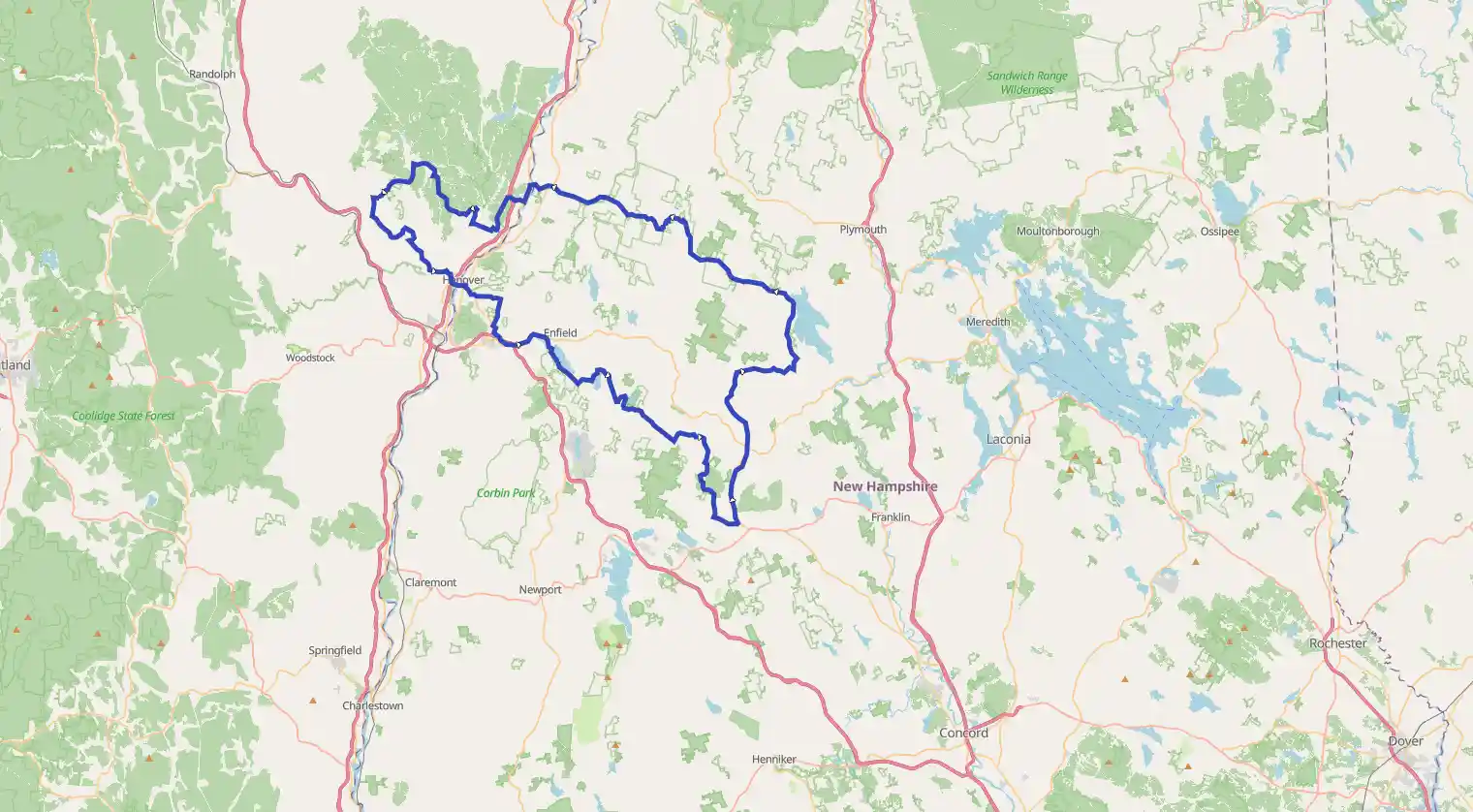
Enfield, New Hampshire, United States
Easy
Completed
Distance 201.31 km
Est. duration 00h 00m
Elevation Gain 3034 m
Elevation Loss 3036 m
Category Biking
Description
Route
Start
3 m
Control (Photo) -- Shaker Museum
43.61973, -72.1469423.29 km
DO NOT GO STRAIGHT
43.53393, -71.97270It will be a wet and bumpy ride
28.64 km
Control (Photo) -- Dean Rd & Danbury Woods Rd
43.52960, -71.9255441.46 km
Control photo NH-4A and Campground Rd
43.44331, -71.8909252.63 km
Danbury Country Store
43.52612, -71.8623372.44 km
ALTERNATE PAVED SECTION
43.62352, -71.7816072.48 km
ALTERNATE PAVED SECTION
43.62806, -71.7662073.42 km
Start of ~2 mile Class VI segment
43.62976, -71.7957976.27 km
ALTERNATE PAVED SECTION
43.65029, -71.7895178.05 km
ALTERNATE PAVED SECTION
43.66729, -71.7916981.44 km
Control (Photo) - Hebron Village Store
43.69423, -71.80650Great little general store for resupply M-Th: 6AM - 6PM Fr,Sa: 6AM - 8PM Su: 6AM - 3PM
85.88 km
Sculptured Rocks Natural Area
43.70679, -71.85633Cool glacial carving into the rocks. A local swimming hole in the warmer months
93.09 km
Foot crossing of South Branch of Baker River
43.73071, -71.9296897.91 km
Cummings Pond Rd impassable
43.76425, -71.95331It may look like there is a shortcut to the left, but there is not!
98.67 km
Flowy MTB Start
43.77094, -71.95545100.25 km
On the way to Spur Trail
43.78732, -71.96495101.19 km
Spur Trail turnoff to left
43.79367, -71.97291101.21 km
More Spur Trail
43.78798, -71.99179107.15 km
Gravel Rd alternate route rejoins
43.77780, -72.01578107.15 km
Turn left for Norris Rd
43.79736, -72.01190120.28 km
Lyme Country Store
43.81069, -72.15671Good stop for food and soft-serve ice cream
120.45 km
Lyme Park & Ride
43.81088, -72.15857Plentiful parking
135.60 km
ALT ROUTE: Turn right onto Pattrell Rd
43.75518, -72.27843135.60 km
Control (Photo) -- Pattrell Rd & Middle Rd
43.76994, -72.27607150.42 km
Coburns' General Store
43.83398, -72.36067159.14 km
Control (Photo) -- Carpenter Rd & Dyer Rd
43.79824, -72.42427176.90 km
Huntley Meadows Park & Ride
43.72478, -72.31443Easy parking for access to the route.
180.24 km
Control (Photo) -- Dartmouth Green
43.70250, -72.28805190.12 km
Lebanon Town Parking
43.64452, -72.24981Tons of parking here if all other lots are full.
190.12 km
Omer and Bob's
43.64282, -72.25328192.44 km
Obstructed View - Covered Bridge
43.63886, -72.22253192.86 km
Northern Rail Trail Access Lot
43.63818, -72.21766Generally plenty of parking available here for the route
198.17 km
Jake's Market & Deli
43.64460, -72.14431Nice convenience store with good subs and wraps
199.40 km
Mascoma Lakeside Park
43.63514, -72.15500Good parking and a nice spot to eat.
199.40 km
Hoptimystic Brewing
43.64111, -72.14752Nice brew spot with pizza and food pop-ups
201.31 km
Control (Photo) -- Shaker Museum
43.61991, -72.14699201.31 km
Finish