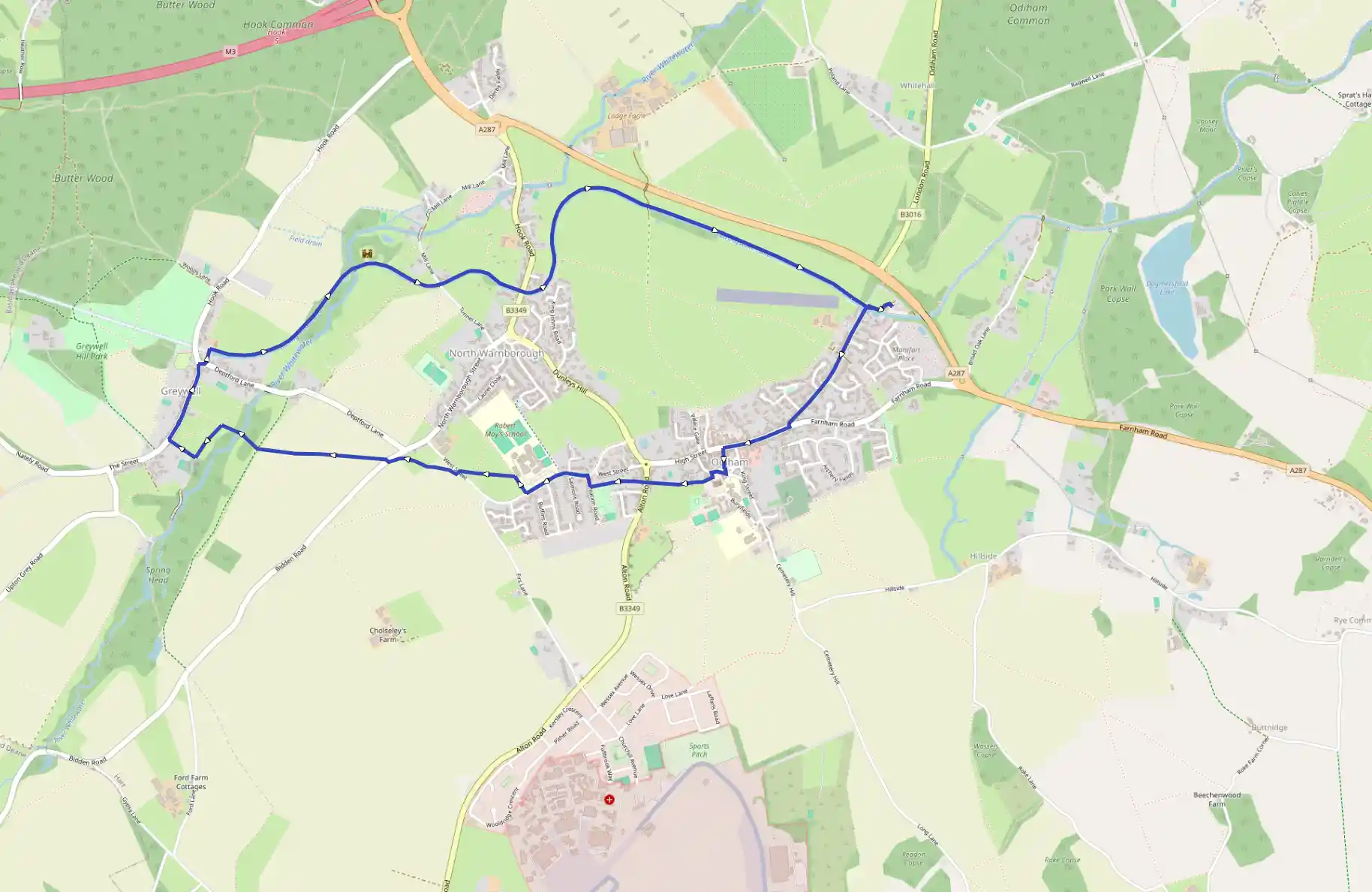
Setting off through the appealing little market town of Odiham, the walk strikes out across farmland to Greywell village before concluding with a delightful waterside stroll along the Basingstoke Canal towpath. It's worth taking the time to explore Odiham, and there's also plenty to look
This is a demo instance. Do not store any relevant data here. You
can use the user 'demo' and password 'password' to login.
Odiham and the Basingstoke Canal
May 16, 2025
by  @robertclarke64@wanderer.robertclarke.co.uk
Hart, England, United Kingdom
Moderate
Distance 7.76 km
Est. duration 01h 27m
Elevation Gain 40 m
Elevation Loss 39 m
Category Hiking
Description
Route
Start
12 m
Start
51.25946, -0.93006Walk back up London Road past the Waterwitch pub and bear right along the High Street. Cross the road opposite the Bel and the Dragon and walk up the narrow alley straight in front of you. Bear right at the top of the alley into The Bury, then turn left into All Saints' churchyard. Now turn immediately right along the wide gravelled path that leaves the churchyard between high walls. Cross Alton Road, and then head along the enclosed path and beside playing fields to reach Recreation Road. Turn right, then left into West Street and walk past Robert May's school.
1.30 km
51.25236, -0.95199
Just beyond the school, turn right up the steps onto a signposted footpath; then, after 80 yards, turn left over the stile and strike half-right across the open field to the stile farthest on the right on the far side. Cross the road, go through the gap in the opposite hedge, and bear right across the corner of the field. Go through the next hedge gap, heading diagonally to the gap in the left-hand corner of the next field, then turn right beside a steel barrier to reach Bidden Road. Cross the road, turn left along the verge for 50 yards and turn right through a gap in the hedge. Now bear left and follow the path across the field, heading gently downhill to a kissing-gate hidden in the hedge at the entrance to Greywell Moors Nature Reserve. Keep ahead past the E C Wallace memorial stone to a second kissing-gate; cross the river and a squeeze-stile, then bear left and walk parallel with the field edge on your left to reach the kissing-gate at St Mary's Church.
2.27 km
51.25348, -0.97201
Turn right down the church path towards the village, then right again at the lychgate to follow the village road as far as the junction with Deptford Lane, just beyond the Fox and Goose pub. Turn right here, then almost immediately left up the waymarked footpath that leads up and over the eastern portal of Greywell tunnel. Follow the path as it swings to the right and drops down onto the towpath, then settle into your stride for the delightful waterside walk all the way back to Odiham Wharf. After ¼ mile (400m), look out for Odiham Castle on your left. Built about 1207, this small fortress was constructed as a resting place where King John could stop and hunt on journeys from Windsor to Winchester. In 1216 the castle was beseiged for 15 days by the French, who were so impressed by the defenders' courage, that they were freed after they had surrendered.
3.58 km
51.26006, -0.95225
Continue beneath Swan Bridge for the final 1¼ miles (2km) to the finish. The canal bends left, then right, before heading straight for Odiham with the A287 for company across the fields on your left. The long straight ends at Odiham Wharf, just beyond the London Road bridge; turn left here to return to the car park where your walk began.
7.76 km
Finish